Vienna Transit Maps 1.3-3
Free Version
Publisher Description

Vienna Transit Maps - Public Transport Network Maps for Vienna. Offline. Reliable. Fast.
With this app you have the maps of the public transport system of Vienna always with you.
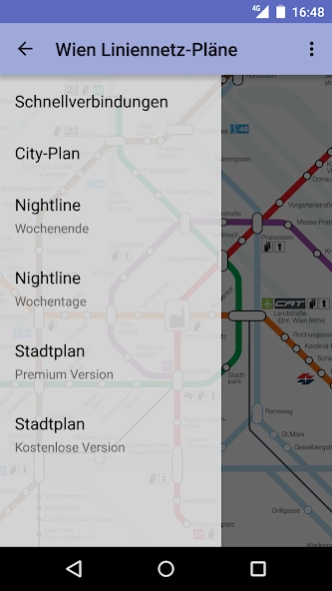
Included plans:
* Rapid transit
* City-Plan
* Nightline (Weekend)
* Nightline (Week day)
About Vienna Transit Maps
Vienna Transit Maps is a free app for Android published in the Geography list of apps, part of Education.
The company that develops Vienna Transit Maps is Topobyte.de. The latest version released by its developer is 1.3-3.
To install Vienna Transit Maps on your Android device, just click the green Continue To App button above to start the installation process. The app is listed on our website since 2023-08-20 and was downloaded 1 times. We have already checked if the download link is safe, however for your own protection we recommend that you scan the downloaded app with your antivirus. Your antivirus may detect the Vienna Transit Maps as malware as malware if the download link to de.topobyte.transportation.plan.aut.wien is broken.
How to install Vienna Transit Maps on your Android device:
- Click on the Continue To App button on our website. This will redirect you to Google Play.
- Once the Vienna Transit Maps is shown in the Google Play listing of your Android device, you can start its download and installation. Tap on the Install button located below the search bar and to the right of the app icon.
- A pop-up window with the permissions required by Vienna Transit Maps will be shown. Click on Accept to continue the process.
- Vienna Transit Maps will be downloaded onto your device, displaying a progress. Once the download completes, the installation will start and you'll get a notification after the installation is finished.
